The travails of geezerdom in Chamonix turned out to be as I had expected—actually, almost too much for un vrai vieillard like me. Paul (a mere child) was the soul of patience. We had a fine week, even though having had to abandon our attempt on the Dent du Géant (4,000m). I am sure that my potting along at about three times guide-book time tried Paul’s patience but he never let on about it.
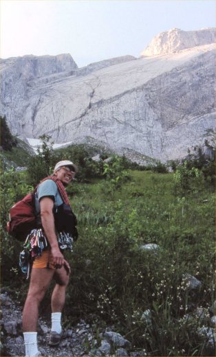
On arrival in Chamonix we settled in to our digs at the gite Les Grands Charmoz. For a week or so the weather—having been unseasonably warm—had prevented the névé from refreezing each night above 2,000m and the guides talked of the undue dangers of soft snow. And so, while awaiting some forecast cooler weather, we decided at first to go to Solalex in nearby Switzerland for a climb that I had heard of called Le Miroir D’Argentine. [1] From the valley its smooth, high limestone face—especially when wet—gleams like a mirror in the sky.
Our climb comprised ten pitches (one of 5.8+) on the 400m limestone face. After slogging for an hour to the base Paul led the early—hard—pitches while I managed a couple above at the 5.6 level. On the first pitch there was a desperate spot—La Boite des Lettres—where the protection was set far above the hard move; I don’t know how Paul managed it; I found it desperate. We liked the climb—clean, challenging, and airy.

The descent, however, proved a misery. After losing the descent trail among flocks of fleeing, defecating sheep and curious, persistent attack goats we found a way down (not the guide-book route) just as an afternoon storm soaked us to the skin. The rain turned the steep, down-slabbing, and dusty trail into a quagmire down which we had to slip and slide on our butts through the mud, and even to rappel off trees with muddy ropes to save ourselves from slimy death. We might better have rappelled the route itself.
Having no dry clothes in the car, and no possibility of finding a restaurant open upon our return to Chamonix, we stopped in Villars for an elegant meal, with wine and paté, which we suffered through shivering in our wet duds and sodden socks. We all understand that mountaineering has a well earned reputation for fun.

After a day of preparation at the gite—ropes through the washer-dryer—the weather did get cooler and we set off early the next morning on the cog-train to the Mer de Glace station at Montenvers [2]. Having negotiated the steep local ladders down the cliff to the glacier we spent the day hiking its length; negotiating the tortured ice and morainal terrain. Fortunately the glacier was “dry”—no snow—making the crevasses visible. After a final 200 meters of vertical ladders and steps we reached the Refuge du Requin at 2,500m . From there we could survey the entire Mer de Glace and its confluence with the Glacier de Leschaux [2], Les Drus and the backside of L’Aiguille Verte, L’Aiguille de Moine, Les Grands Jorasses, the Dent du Géant (our vaunted objective), and the tortured Seracs du Géant ahead through which we planned to thread our way the next morning.
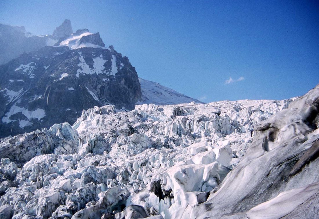
The maitress assigned us the bunk room for the Torino hut (up at 5:00a) and after breakfast we plunged into the ice-fall not having a clue as to whether we could or would find a path through to the Vallée Blanche above. Paul proved a great route finder and, between the two of us, trying this, and probing that route in the jungle of crevasses and seracs, we soon passed most of the other parties (some roped and guided) who seemed to spend much time placing anchors and belaying instead of moving continuously along. Occasionally roped, we jumped across voids and single-tooled up endless short ice walls with axes and crampons, gradually gaining easier terrain in the region of La Bedière above a rock prow jutting from the snow called Le Petit Rognon.
Our speed then subsided into my codger’s slow slog—we’d reached an altitude of 2,800m—which persisted through the rest of our long day’s journey into height. We moved up and across the Vallée Blanche toward the Torino hut (3,400m) on the alps Italian side. The sun blazed, we slathered on sun-block, argued over the route (I, naively, for an apparent direct route and Paul for the much longer but obviously well-traveled one), took photographs, and forged—I breathlessly—ahead. We descended the final and seemingly endless steps from the Col des Flambeaux down to the hut to exchange our loads (Paul had graciously carried the heavier one) and our boots for cold beer and food.

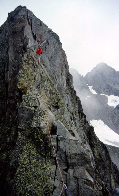
We shared dinner with some personable Alpine Club guys from New Jersey who had spotted my AAC t-shirt and hit the sack early in anticipation of an alpine start (3:30a) the next morning for our attempt on the Dent (4,000m). One reaches summit pinnacle after about five pitches of technical rock above a small snowfield: La Salle à Manger (3,800m).
At 11,000 ft. I found the going agonizingly slow. At first it seemed that with our early start we might have a chance at the summit and our spirits reflected our hope. However many parties passed us, first in the dark, and later on the final snow slopes and on the many class-four rock pitches below the Salle à Manger, which we did not reach until noon with several parties queued up ahead of us for the final technical pitches. We rested and had a bite while the heretofore sunny weather suddenly loomed down in cold fog only to clear moments later and then to descend again in misty swirls for long minutes at a time. We found this highly unsettling but our final decision to bag the climb hinged on the lateness of the day, the parties ahead, and my reluctant admission that I didn’t have five technical rock pitches left in me. To have reached the summit at four or possibly six in the afternoon followed by a five hour return to the hut seemed unnecessarily daunting. We bailed.

The next day we descended to Courmayeur, the Chamonix of Italy, to look around and to have lunch after Paul had found some old prints to buy in an antique shop. Courmayeur seems less frenetic, more forested, and more handsome than Chamonix.
Then we rode all the téléferiques in series—to the Punte Helbronner, the télécabine to the Midi high station, and thence down to Chamonix where we walked to the cog railway station to complete our circuit. Luckily Cheryl Berry had a room for us at the gite where Yuki Fujita, a climbing friend from Boston, had just arrived for a three week stay. We loafed around the next day and on our last went to Les Praz to take the téléferiques Le Flegère and L’Index to climb a fine arête on L’Index (an embarrassingly low number in Rebuffat’s 100 Finest [3]) reminiscent of the Whitney-Gilman ridge on Cannon Mountain in New Hampshire.
Paul flew back while I boarded the TGV to Paris and Rennes to spend a week with my old ice climbing friend at his house in La Bouëxière where I earned my keep at le bricolage as carpenter, plumber, electrician, and layer of parquet flooring.
-o0|0o-
Notes:
[1] https://www.camptocamp.org/routes/53893/en/miroir-d-argentine-voie-directe#&gid=1&pid=4
https://www.mountainproject.com/area/107646478/le-miroir-dargentine
[2] Today (2018), under global warming, the snout of the Mer de Glace no longer reaches the cog station at Montenvers (an erstwhile tourist mecca). And its confluence with the Glacier de Leschaux has vanished.