Le Glacier de Leschaux et La Mer de Glace, Chamonix [Editions ANDRE]
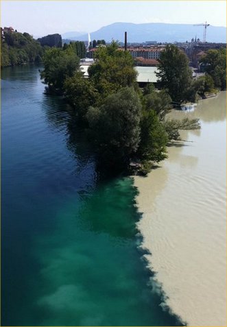
At Geneva in Switzerland the river Arve flows a majestic and translucent milky white as it drains much of the province of the Haute Savoie—the French Alps. As I stand on the point of land at the very confluence of the turbid Arve and, in sharp contrast to the right, the clear, black purity of the Rhône leaving Lac Leman, it occurs to me to wonder how this tenuous and ghostly passage could rationally be related in time to the magnificence of the mountains towering over the valleys of the glaciers and streams that produced them [1].
I make a wild guess that the Arve carries an average suspended burden of erosional silt and glacial rock-flour in the amount of 1.0mm^3 /1000cm^3—a cube about the size of the head of a pin in one liter of water (one part per million).
The ultimate erosion rate is probably more than I guess for my estimate omits unseen dissolved minerals and organics, the mass transfer of material along the river bed itself in the form of the roll and wear of non-suspended sand and pebbles during floods, and the organic detritus which floats on the surface as dead twigs, grass, and leaves. The erosion rate could have been hugely greater than this during the peaks of the many ice ages which have gripped the northern hemisphere in the last five-hundred thousand years. But, it is interesting to reflect upon what the vastness of time can do with tiny resources.
I assume now—not so much of a guess—that a rectangle roughly 100km by 50km (5,000km^2 or 5,000,000,000m^2) represents the area, A, of the watershed of the river Arve and its tributaries in which the elevation of the average valley (500m) is 3,000 meters below that of the average summit (3,500m), a difference, of 3,000m. I assume, further, that the volume of this mountainous mass has the form of a quadrilateral pyramid, i.e., of height h= 3,000m, and base A= 5,000,000,000m^2, and thus has volume equal to Ah/3= 5,000,000,000,000 or 5 quadrillion cubic meters (5.0×10^12m^3). Subtracting this from an original solid block hA leaves a remainder 2Ah/3 which has eroded away over time. This equates to 10,000 cubic kilometers or 2,400 cubic miles of solid rock.
Assume the Arve at Geneva—I stand and watch it flow by—is 200m wide, 5m deep on average (10m in midstream), and flows at a rate of about 5,000m/hr (an average walk). The volume of flow is then 5,000,000m^3/hr and, hence, carries a milky load of 5.0m^3/hr; the equivalent of an annual erosional volume of a mere 40,000 cubic meters per year.
However, at this rate the Arve (as it exists today) would have required only 250 million years to carry away the rock volume of the valleys of the Haute Savoie from an initially level plain of elevation 3,000m; a short time geologically, and well since the appearance of the first fossilized life forms 600 million years ago. The earth is 5,500 million years old and the life upon it about 3,000 million years. [2]
To translate this into a rate of average lowering of the terrain, we can divide the annual erosional volume (40,000m^3/yr) by the area of the watershed (5,000,000,000m^2) to get 0.000008m/yr, or less than one millimeter every 100 years. This rate is pretty easy to imagine as happening everywhere, continuously and yet virtually undetected before our very eyes. Of course the rate is smaller where terrain is more or less broad and level and higher where it is narrow and steep.
The Arve, of course, was not, and never was, as it is today. It did not exist as such, even probably, as recently as 100 thousand years (several ice ages) ago. Further, the highest points undoubtedly began as much lower regions gradually elevated during the erosional process by the inexorable northward drift and collision of the African continent through the process of plate tectonics. Furthermore, the silt load varies with season. So then, of what use my estimate? It serves only as an example of what deep time can accomplish with the tiny effects we see around us today; and to illustrate the feasibility and the fun of getting a feel for reality by simple and rational means.
This article first appeared in The Crux; a publication of the Appalachian Mountain Club, Boston Chapter Mountaineering Committee. Editors: Al Stebbins and Nancy Zizza.
[1] At Geneva the Rhone flows clear and black because its sediments have settled out at its mouth, far away at the eastern end of Lac Leman.
[2] Today the Mer de Glace at Chamonix has retreated so far up the valley that it is no longer visible from the tourist terraces at Montenvers. Its confluence with the Glacier de Leschaux (prominent in the banner photo’ ca 2000) no longer exists as this flow, too, has vanishhed almost to the base of the Grandes Jurasses.
_

One thought on “Reflections on a Time-Scale for the Formation of the Alps of Chamonix (~1980)”